
Finding Naugatuck Streets By Address
A Naugatuck street directory search should move from the broad map to the stable parcel key, then to the record that answers the question. Begin with the exact street string and house number. If the first search fails, keep the original wording and test the portal’s street list, directional prefix, suffix, unit, old name, or nearby town label. Never erase a unit or turn a historic address into a current one without a dated source.
The street walkthrough below keeps the steps in order. It is useful for a parcel, a street segment, or a house-history question. It does not create a list of people. The goal is to find the right record creator and then read only the fields needed for the research.
- Search Naugatuck GIS by house number and street, or by owner name, account number, or MBL.
- Open the related property card and note location, owner field, property use, MBL, assessment, building, and sale fields with the checked date.
- Use the MBL or owner as a bridge to the Town Clerk’s deed and map index, then save instrument, book, page, and legal-description details.
- Compare the property location with mailing and postal data through CAMA or USPS, keeping the two address types separate.
- For an older occupant clue, search a dated directory or newspaper and verify the entry with a deed, vital, map, or second dated source.
A street directory is strongest when it records a source trail, not when it presents a guessed household. An MBL can remain useful after a name, owner, or postal format changes.
Naugatuck GIS Search Fields
The Naugatuck GIS property search exposes the fields most useful for a by-address start: Property Search Name, House No, Street, Account Number, and MBL. Search and reset controls are visible. The parcel map and property-information notices were checked in the research on a current 2026 run. The map notice says parcel maps were updated in May 2026 and property data updates every Friday.
| Property Search Name | Use the name field as a lead, then confirm the returned street and parcel. |
|---|---|
| House No | Pair the number with the portal’s street selection; keep unit information separate. |
| Street | Select the municipal street label instead of relying on an untested abbreviation. |
| Account Number | Use the local account key when a name or street string is ambiguous. |
| MBL | Use map, block, and lot as the cross-system bridge for property and deed work. |
GIS property information is not a resident directory. A selected parcel can show an assessment owner or map feature, but it does not prove current occupancy. The map is also not a substitute for a recorded deed when a legal boundary or title point matters.
The Naugatuck GIS property search shows the local address and parcel controls represented by this capture.
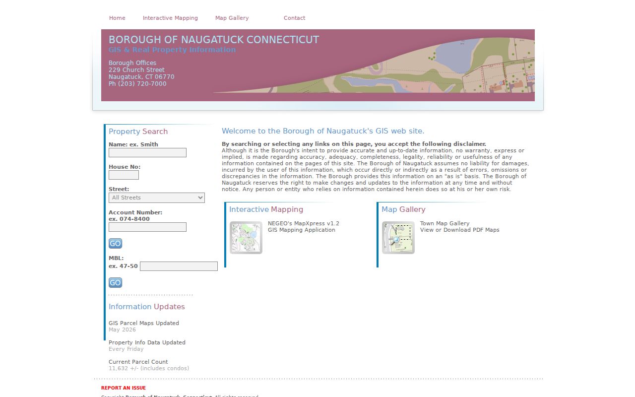
Record the visible search key and date before moving to a different Naugatuck record system.
Naugatuck Parcels And Property Cards
Naugatuck’s property-card interface uses Property Use, Owner Name in Last First order, location number, location name, unit, street, MBL, unique identifier, condominium complex, search, and reset controls. A separate sales search can filter property type, sale-date range, price range, acreage, MBL text, zone, location, design, living area, year built, rooms, bedrooms, and bathrooms. Those controls describe assessment and sales records, not a household census.
Read the card as a dated record. Owner, co-owner, property use, location, mailing address, assessment, sale, building, permit, and inspection fields each have a different scope. The state CAMA schema adds property ZIP and mailing ZIP, but a field inventory is not proof that every local screen displays every value. Compare the MBL and location first.
- Parcel
- A mapped land unit identified by a local key such as MBL or account number.
- Property use
- The use category assigned by the assessment system; it is not a statement about who occupies a property.
- Mailing address
- The destination for assessment or tax correspondence, which may be outside Naugatuck.
- Property location
- The physical situs of the parcel, which can differ from the mailing field.
Note: Compare owner and occupant questions separately; an assessment owner may not be the person present at a Naugatuck address.
Naugatuck Deed Index Coverage
The Town Clerk is Naugatuck’s land-record custodian. SearchIQS provides the online entry and a coverage note, but its record eras have a visible seam. Land-record index data and images run from 01/02/1991 to the present. Grantor/grantee index books cover 1983-1990, and record-book images bridge 12/30/1982 to 01/07/1991. Maps reach back to 04/26/1854. A gap in a current search may mean the search needs the earlier book or a town request.
The Naugatuck SearchIQS coverage guide identifies these ranges. The search screen can use Party 1 or Party 2, individual last and first name, partial names, wildcard asterisk, date From and Thru, document group, document description, town, book/page, instrument number, and case number. Image download or print pricing was shown as $2 per image in the captured route, while a Naugatuck-specific certified-copy fee was not located.
For a deed chain, start with the assessment owner as a grantee lead, retrieve the purchase instrument, record the seller and book/page, then search that seller as a grantee. The index is a finding aid. The Town Clerk is the place to ask about certified copies, older books, and a record that cannot be read from the public screen.
See the SearchIQS coverage guide for the date seam represented here.
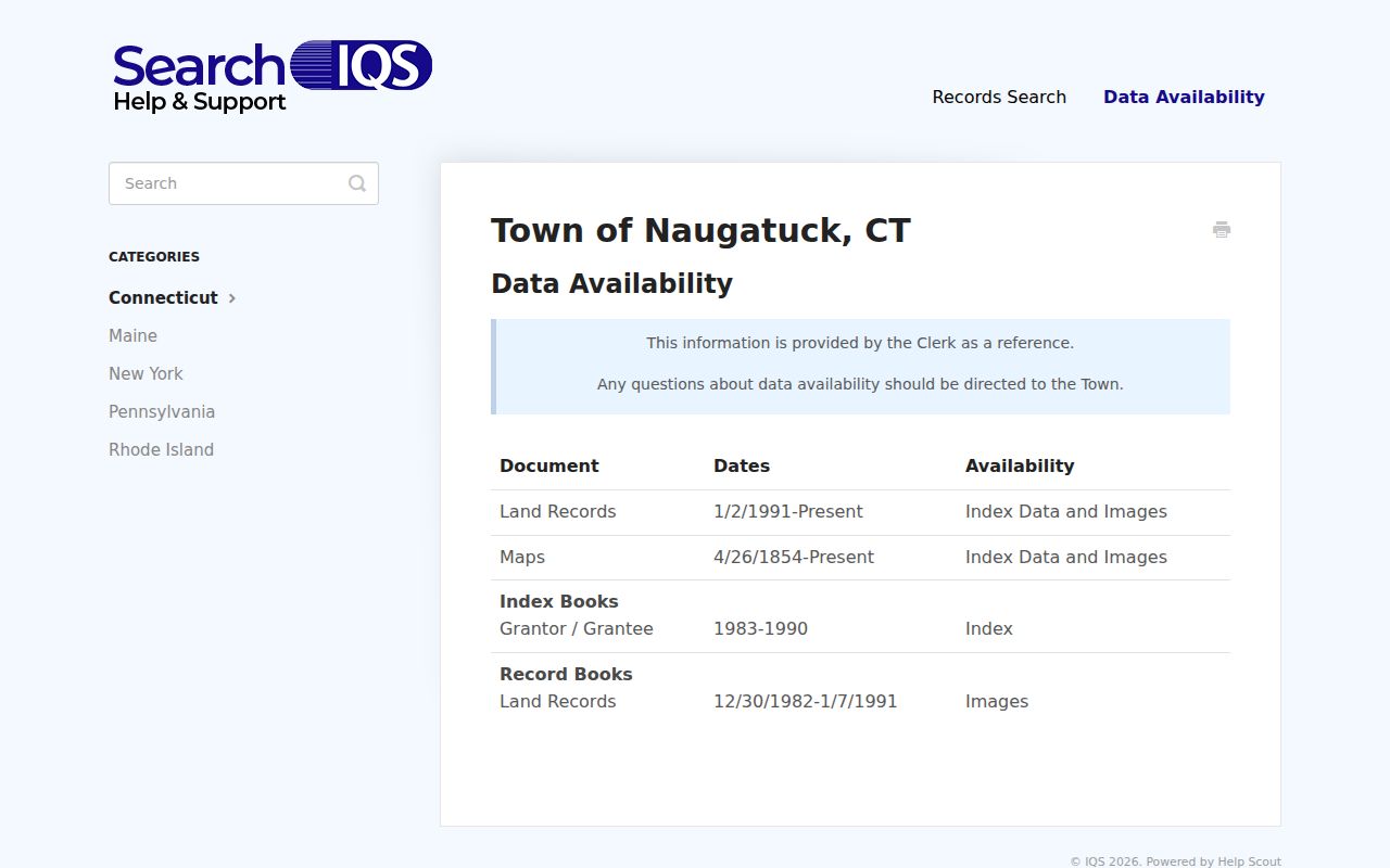
A street directory should label a deed result as a recorded party trail, not as a list of current residents.
Naugatuck Records By Street
Address-keyed sources overlap, but they do not carry the same kind of fact. This coverage table keeps the street directory precise and points to the right fallback when an online result stops.
| Street / Address Task | Source | Useful Fields | Caveat |
|---|---|---|---|
| Locate a parcel | GIS | Street, house number, MBL, account, parcel outline | Map is not a resident list |
| Read assessment | Property card / CAMA | Owner, use, location, mailing, assessment, sale, building fields | Date and revaluation basis matter |
| Follow ownership | Town Clerk / SearchIQS | Grantor, grantee, recording date, instrument, book/page | Coverage changes by era |
| Check a nearby parcel | GIS map selection | Boundary, MBL, selected layer, map date | No radius tool located |
| Verify postal form | USPS | Standard street, city, state, ZIP, ZIP+4 | Postal match does not prove a person |
| Find an older occupant clue | LOC / NARA / library | Edition, page, surname, street, address, notation | May list a subscriber or contact |
When the question shifts from a full street to one person, a separate Naugatuck resident lookup keeps name matching, court, vital, probate, and credential checks in their own lane.
Naugatuck Map Layers And Segments
The Naugatuck GIS map offers more than a parcel outline. Visible layers include zoning, voting information, FEMA flood data, NVCOG open space, DEEP environmental layers, 2005 and 2012 aerials, 2017 and 2020 pictometry, 2022 and 2023 aerials, and Grand List sales colors for 2021-2025. Select and Pan tools help inspect a street segment one parcel at a time.
Define a segment before comparing records. Use cross streets, a parcel range, a map extent, or a named landmark. Save the visible layer names and date. List MBLs as stable research keys. Use deed descriptions for legal boundaries and aerials for visual change. If the task says nearby, state whether nearby means adjacent parcel, same street segment, or a map-visible cluster. The viewer did not expose a clear radius or buffer control.
GIS layers can show flood, zoning, environmental, or sales context around a street. They do not tell who is inside a building. A Naugatuck street directory becomes clearer when the map layer is named beside the record type.
Naugatuck Permits And Land Use
Building and land-use records can explain why a parcel trail changes. The Building Inspector route covers permit, inspection, and code records, but the municipal page says searches are by appointment. The research lists 203-720-7035 and Building@naugatuck-ct.gov. Exact public search fields and an online result screen were not located, so a street directory should present the appointment route instead of promising a portal.
The Land Use Office holds zoning, subdivision, wetlands, and Plan of Conservation and Development material. The inspected copy schedule lists $0.25 copies, $30 zoning regulations, $15 wetlands, $20 subdivision, a POCD fee of $20 unbound or $50 bound, a $5 PDD supplement, and a $4 zoning map. Current-page dates matter: zoning regulations were listed as effective December 2024 and subdivision regulations as effective April 2024.
Review the Naugatuck Building Inspector page before asking for a permit search; it is the source represented here.

Appointment-only access is still an access channel. A request path is more useful than an unsupported claim that permit results are online.
Naugatuck Postal Address Checks
USPS answers a postal question, not an occupancy question. Its address mode accepts a company as optional, street, apartment or unit, city, state, and optional ZIP. City/state and ZIP/city modes answer different questions. The Naugatuck USPS location is listed with 06770-9994, while the research supports 06770 as the primary Naugatuck ZIP starting point.
Run the exact address through the USPS ZIP lookup, save the standardized form and date, then compare it with the GIS street label, property location, CAMA Property Zip, and Mailing Zip. A ZIP+4 result is delivery-specific. A difference between mailing and property ZIP is a data distinction, not an error to hide.
Note: USPS warns that a ZIP match does not confirm that a particular person or company is associated with the address.
Naugatuck Historical Street Names
Older street research needs both the original label and the modern equivalent. Naugatuck’s official plan and local history use the Naugatuck River, industrial areas, Union City, historic districts, and neighborhood planning as recurring geographic anchors. A historic map may describe a village, mill, road, or landowner rather than a USPS street address. The 1856 New Haven County map includes a Naugatuck ancillary map and landowner context.
The Library of Congress and National Archives Waterbury locality reels include Naugatuck in the late 1920s and early 1930s. Search the locality guide and record the edition, page, street, and notation. The historical directory collection is treated in depth on the Naugatuck directory book page, while the street directory keeps the current address chain.
Preserve old and new labels side by side. Do not infer that the same family stayed at a street address because a name appears in two editions. Deeds, maps, newspapers, vital records, and property keys are the checks that join time periods.
Naugatuck Street Directory Limits
A street directory cannot show every person who is present. The assessor records assessment ownership. A deed records parties to an instrument. A voter result is administrative and time-sensitive. A historical directory may list a subscriber or household contact. A business filing can show a registered address. None of those fields alone establishes a complete household, current occupant, relationship, or personal circumstance.
Connecticut privacy tools include Safe at Home, voter nondisclosure under CGS §9-50(d), residential-address protection under CGS §1-217, sealed or protected court records, and vital-record restrictions. An absent result can reflect privacy, spelling, coverage, or removal. Keep protected addresses, full birthdates, IDs, phone numbers, and personal email out of a street research note.
Lawful street research. Use address records for parcel history, family history, civic context, map study, and scam verification. Do not use a street search to stalk, harass, threaten, or harm a person.
For a responsible Naugatuck street directory entry, include the source, record type, date checked, stable key, and a short statement of what the record does not prove. That format protects the reader from overreading a public field and gives the custodian a clear follow-up question.