
Naugatuck Neighbor Lookup Sources
A block lookup should begin with the source that can show geography, then move to the record that supplies the needed fact. A Naugatuck neighbors search should name whether it is tracing adjacent parcels, a street segment, or a civic network. The table keeps a nearby parcel, civic network, and historical clue from becoming one unsupported household profile.
| Source | What It Shows About A Block | Access |
|---|---|---|
| Naugatuck GIS map | Adjacent parcel outlines, streets, MBLs, layers, aerial change | Public viewer; select parcels manually |
| Property cards / CAMA | Owner, use, location, mailing and property ZIP, assessment, sale fields | Public search; date the result |
| Town Clerk / SearchIQS | Deed and map chain for a selected parcel | Online coverage plus clerk fallback |
| Registrar / SOTS | Registration and polling information under state rules | Individual lookup; no bulk copying |
| Parks and civic groups | Community-network leads and organization names | Public activity pages; no membership roll |
| POCD and land-use files | Neighborhood planning, Union City, zoning and preservation context | Official plans and copy request |
There is no official Naugatuck neighborhood-association or HOA directory in the located research. That gap should be stated plainly. A civic organization page is a community lead, not proof that a nearby person belongs to it.
Mapping Naugatuck Blocks
The Naugatuck GIS map viewer uses Select and Pan tools, a layer selector, map grid, legend, print map, measure tools, and reset or full-extent controls. It exposes parcel, zoning, voting, FEMA flood, NVCOG open space, DEEP environmental, aerial, and Grand List sales layers. The visible map is the starting geography for a Naugatuck neighbor lookup.
Move from one address to the surrounding parcels in a defined order:
- Search the starting address and note its parcel boundary, street label, MBL, account, and map date.
- Pan or zoom to the next parcel that touches the boundary or shares the chosen street segment.
- Select one neighboring parcel at a time and record the MBL or account rather than copying a full personal profile.
- Open the property card or CAMA fields only for the record question at hand, and label owner, mailing, situs, or use.
- Use the Town Clerk deed or map route to verify a boundary or transfer when the map is not enough.
The viewer did not expose an explicit radius or buffer tool. “Nearby” must therefore name the method: adjacent parcel, same segment, map cluster, or a town-defined area.
The Naugatuck parcel map shows the layers and selection context represented by this capture.
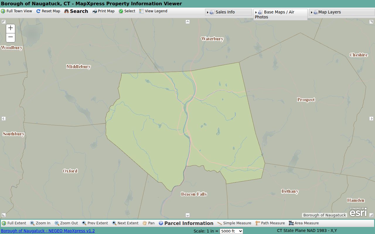
A map can show the shape of a block. It does not turn the block into a public household directory.
Naugatuck GIS Layers
Layer choice changes the meaning of a neighbor map. A Naugatuck neighbors map can use zoning to frame permitted land-use categories, while FEMA flood and DEEP environmental layers add context. Voting information and polling geography describe civic administration. Aerial years show visual change. Grand List sales layers show a dated sales visualization. NVCOG open-space and planning layers add regional context.
Do not read an environmental, flood, zoning, or sales color as a statement about a person. Save the layer name, visible legend, and date. Use the assessor for assessment ownership, the Town Clerk for deeds and maps, and USPS for postal form. The GIS map is a bridge among those records, not their replacement.
Note: A map layer can describe land or planning context without identifying a household, relationship, or current occupant.
Naugatuck Adjacent Parcel Keys
MBL and account numbers are the cleanest stable keys for an adjacent-parcel study. Names can repeat or change. Street strings can be normalized differently. Mailing ZIPs can differ from property ZIPs. A parcel key helps connect GIS selection, property card, CAMA row, deed instrument, and map reference without publishing more personal detail than a neighbors lookup requires.
The property-card search exposes owner, location number or name, unit, street, MBL, unique identifier, condominium complex, use, zone, buildings, and sales filters. The statewide CAMA schema adds Property ZIP, Mailing ZIP, owner, co-owner, assessment, sale, occupancy, and geography fields. The schema does not guarantee that every Naugatuck screen returns every field.
- Adjacent parcel
- A parcel that touches the selected parcel in the map record, not a person assumed to live nearby.
- MBL
- Map, block, and lot key used to connect local property and deed sources.
- Situs
- The physical parcel location, distinct from mailing or registered-agent address.
- Map-visible cluster
- A stated group seen in a defined map extent, without claiming a precise radius.
Naugatuck Voter Block Context
The Naugatuck Registrar maintains the town registry, annual canvass, registration process, and polling information. Connecticut’s centralized system contains town records and may include participation history. A voter lookup can answer a registration or polling question, but it should not be used as a block roster.
The 2026 public-file rule under Public Act 26-1 §96 releases only year of birth, with month and day exempt. Voter nondisclosure under CGS §9-50(d) is available when disclosure threatens safety. A full file request is a separate $300 process with limited permitted purposes and prohibitions on personal, private, commercial, marketing, harassment, and reproduction uses.
For a Naugatuck neighbor lookup, link to the official voter route and keep the current date. Do not publish voter IDs, full birthdates, participation histories, or protected addresses. An active or inactive status is administrative and time-sensitive.
Naugatuck Civic Network Leads
Neighbors can also mean people connected through a local activity rather than an adjacent parcel. A Naugatuck neighbors search may therefore begin with a civic-network lead. Naugatuck Parks and Recreation material names Peter J. Foley Little League, Union City Little League, Naugatuck Basketball Association, Naugatuck Youth Soccer, Naugatuck Pop Warner, and YMCA Little Pal. These are organization names, not neighborhood membership rolls.
| Recreation groups | Useful for activity and community context; ask the organization about current public information. |
|---|---|
| Historical Society | Picture files, yearbooks, manuscripts, directories, and local-history interpretation. |
| Whittemore Library | Newspapers, genealogy, Connecticut resources, and research databases. |
| Arts and civic sources | Public meetings, Arts Commission, Cultural Council, and town notices. |
The research found no complete official neighborhood-association directory. Use public activity pages to learn the network, not to infer that an address belongs to a group.
Naugatuck Planning And Union City
The 2023 Naugatuck Plan of Conservation and Development provides a place frame for neighbor research. It connects the 1701 settlement, Naugatuck River, industrial and rubber history, historic districts, and neighborhood planning or preservation. Union City appears as a distinct geographic and historical reference. An old newspaper, map, or directory may use that label even when the current municipality is Naugatuck.
Land-use copies have a published schedule in the research: $0.25 copies, $30 zoning regulations, $15 wetlands, $20 subdivision, POCD $20 unbound or $50 bound, $5 PDD supplement, and $4 zoning map. Current regulation dates were listed as December 2024 for zoning and April 2024 for subdivision. Confirm current fees and versions with the Land Use Office.
Planning context can explain why a block has a certain map shape or historic label. It cannot identify the people who occupy nearby parcels.
Naugatuck Mailing And Situs Clues
Neighbor work often exposes a mailing-versus-situs mismatch. For Naugatuck neighbors, a property location is the physical parcel while a mailing address may be outside town, a PO Box, or a correspondence destination. CAMA and property cards may show both. USPS can standardize the delivery form. A business principal, agent, or registered address belongs to an entity filing, not automatically to a nearby home.
Write down the source label beside every ZIP, street, and city. Compare the exact USPS form with GIS, MBL, property location, and mailing fields. If the values differ, explain the system distinction. A different ZIP does not by itself show a move, a second household, or an error.
Note: Mailing and situs fields can point to the same parcel while answering different questions about a nearby address.
Naugatuck Official And Commercial Tools
Official sources and commercial neighbor tools serve different purposes. An official GIS, assessor, deed, voter, or planning record has a named custodian and a defined field set. The town’s property-fraud alert route is a useful reminder to verify a suspicious deed or notice with the Town Clerk. A commercial tool may combine public and private data, use unknown refresh dates, charge for access, or show a match without the original source. Neither category should be treated as a complete household record.
| Approach | Strength | Limit |
|---|---|---|
| Official GIS / assessor | Parcel, MBL, owner and map context | Owner is not proof of occupant |
| Town Clerk / deed index | Recorded transfers and legal descriptions | Coverage and copy access vary |
| Commercial neighbor category | May combine multiple clues in one interface | Source, date, accuracy, cost, and lawful-use limits may be unclear |
For Naugatuck neighbors, the official source chain is easier to audit. Keep a record date and contact the custodian when the result could affect a person.
Privacy Limits For Naugatuck Neighbors
A nearby parcel is not a household directory. Property records can show assessment ownership. A deed shows recorded parties. Voter information is controlled by state privacy and maintenance rules. Court, vital, juvenile, adoption, protected-party, and Safe at Home records may be restricted or absent. A civic group page does not prove membership. Historical entries do not become current claims.
Use the minimum data needed: parcel key, map layer, source, date, and record type. Link to official portals instead of copying full names, IDs, birthdates, phone numbers, private email, or complete address histories. A respectful reconnection can use a library, Historical Society, alumni, civic, or mutual-contact route without exposing a current address.
Lawful neighbor research. Use a Naugatuck neighbor lookup for parcel context, civic geography, local history, preservation, and scam verification. Never use it to stalk, harass, threaten, or harm anyone.
The responsible ending is a source note: what was selected, what field was read, what date was checked, and what the record does not prove. That is enough to map a block without turning geography into surveillance.